
Professional training and seminar facilitator
Structural Geology for Mineral Exploration (2 to 4-day course and workshop)
by Dr. Matias Sanchez
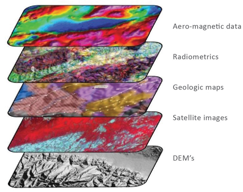
The main objective of this short course is to disseminate basic concepts of structural geology, field techniques and interpretation of geophysical data for more comprehensive understanding and characterization of structural controls on mineralization. The course provides a look at the nomenclature associated with the development of normal, reverse and strike-slip fault systems and their relationship with hydrothermal systems and emplacement of intrusions. The course includes techniques for interpreting remote sensing data, with emphasis on magnetometry, satellite imagery, digital elevation models and drill core data. We focus on the ability to recognize, outline and understand, at different scales, the styles and types of fault and fracture arrays associated with the emplacement and architecture of porphyry and epithermal systems.
Intended for Explorers
This course is intended for explorers who want to delve into a modern structural look that integrates tectonic, structural, metallogenic and geophysical concepts for the vectorization of mineral deposits.
Offered privately or via geological congresses and seminars
We offer this professional training course to the mineral exploration industry, either privately or via open geological congresses and seminars. For the past 4 years we have specifically designed courses and workshop to our clients. We have also partner up with Thomas Bissig, Dick Tosdal and Ken McClay for the Chilean Geological Congress, Chile Explore Congress and the Turkish Association of Economic Geologists. The course can be either taught in English or Spanish.
For additional information please contact
msanchez@faultrocks.com
The short course consists of:
Lectures
Fault systems and controls of mineralization
Structure and emplacement of plutons and dikes
Fractures and vein arrays
Interpretation of DEM, satellite images, geological maps and cross sections
Digital mapping and interpretation of field and drill core data
Structural interpretation of magnetic data
Excercises
Structural geomorphology and GIS techniques using DEMs
Satellite image interpretation and reading geological maps
Structural cross sections
3-point problem in drill and map data
From digital mapping to GIS spatial analysis techniques
Stereonet analysis of fault/fracture/vein data
Structural interpretation of magnetic data
Courses
Structural Geology and GIS for Discovery 2025
Date & Time
23-25 January
Location:
Vancouver, BC
Course Description Document